NJARRETT44
New member
Is anyone in the group familiar with the route taken on the Land Rover Great Divide Expedition from the 80's? A few buddies and I are planning to retrace the original route in our trucks next summer. Any information on the trails they took or an introduction to someone involved in the original event would be a huge help. While there was a decent amount of press for both iterations I haven't found a map that's any better than a rough sketch of the route.
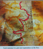
I have a few way points mentioned in the documentary listed below. I'm also borrowing heavily from the Colorado Backcountry Discovery Route and a SW Colorado route published in Overland Journal a while back. The goal is to hit the highlight trails and stick roughly close to the continental divide while minimizing on road time.
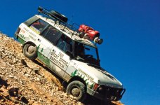
The Great Divide Expedition: A Range Rover Odyssey Through Colorado
I have a few way points mentioned in the documentary listed below. I'm also borrowing heavily from the Colorado Backcountry Discovery Route and a SW Colorado route published in Overland Journal a while back. The goal is to hit the highlight trails and stick roughly close to the continental divide while minimizing on road time.
- Battle Pass, WY start
- Over Hahn's Peak
- Rand, CO
- Rollins Pass
- Red Cone
- Camped outside of Breckenridge, CO
- Mosquito Pass
- Aspen, CO
- Tincup, CO
- Slumgullion Pass
- Ouray, CO
- Imogene Pass
- Telluridek CO
- Ophir Pass
- Chama, NM Finish
The Great Divide Expedition: A Range Rover Odyssey Through Colorado