Trip Plan for Oregon, Idaho?

RBBailey

NAS-ROW Addict
Callsign: KF7KFZ
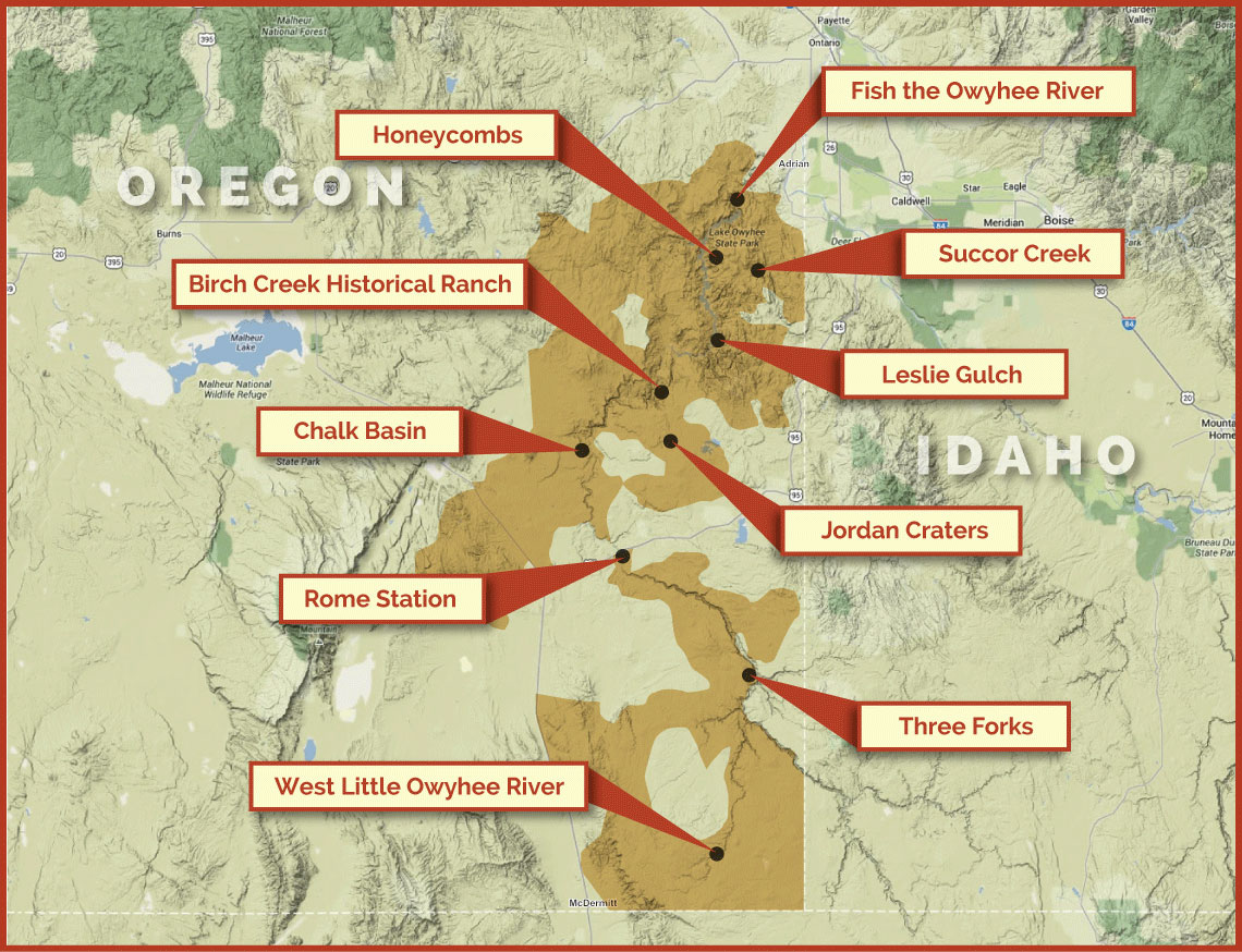
I would like pointers on planning a week in SE Oregon area in late June. I was planning some routes with Gaia, but quit because every time I plan I end up with dead-ends and blocked roads and gates and cutting a week into two days because there never seems anyplace to go anymore. So although I've made many trips into that area, they've always been broken up and cut way short by sickness, weather, other people, or mostly breakdowns. In other words, I've only scratched the surface, and feel very unprepared.

So I'm wondering where you would go? How do you know those are the right places? How did you know before you went? How did you plan? Would you risk taking the Defender solo, or would you rent a car for the week? How do you know?
 

jymmiejamz

Founding Member
Callsign: KN4JHI
We did the Alvord and Black Rock Desert a while ago. There is a nice scenic gravel route at Steens mountain. We got pretty remote in the Black Rock desert and had some serious fuel anxiety, but it was just my wife and me in my D90.
 

chris snell

Administrator
Callsign: NW5W
Staff member
Go to the Owyhee. There are a few spots where you can wade your truck across the Owyhee and Jarbidge Rivers. They are pretty easy to find if you study the satellite view and you should be able to string together routes between those spots. You have to be flexible out there and bring good maps. Good tires are also a must. XZLs are the best possible tire for that place, in my opinion, due to the volcanic rocks everywhere.

When I went there, I went with a collection of points and potential routes. Some turned out to be closed and I re-routed us on the fly.

If the truck is running well and you weren't traveling in it alone, I wouldn't worry about being a solo truck.

You would never want to take a rental car in this area.
 

RBBailey

NAS-ROW Addict
Callsign: KF7KFZ
We did the Alvord and Black Rock Desert a while ago. There is a nice scenic gravel route at Steens mountain. We got pretty remote in the Black Rock desert and had some serious fuel anxiety, but it was just my wife and me in my D90.

Been to Steens Mt. and Alvord a few times. Only got to camp on Alvord once because of the tour bus one time, sick another time, and deep water another! The Black Rock is a thought.
 

RBBailey

NAS-ROW Addict
Callsign: KF7KFZ
Go to the Owyhee. There are a few spots where you can wade your truck across the Owyhee and Jarbidge Rivers. They are pretty easy to find if you study the satellite view and you should be able to string together routes between those spots. You have to be flexible out there and bring good maps. Good tires are also a must. XZLs are the best possible tire for that place, in my opinion, due to the volcanic rocks everywhere.

When I went there, I went with a collection of points and potential routes. Some turned out to be closed and I re-routed us on the fly.

If the truck is running well and you weren't traveling in it alone, I wouldn't worry about being a solo truck.

You would never want to take a rental car in this area.

Yeah, would not do rental there. Was thinking of just a road trip type of camping if that were the only option. (The Defender always seems to break in Spring, and the other vehicles are completely stock.)

Were you always within the Owyhee reserve?
 

chris snell

Administrator
Callsign: NW5W
Staff member
I've never heard of an Owyhee "reserve". We were all over the desert. We were as far east as Jarbidge and as far west as Three Forks, OR. As far south as Winnemucca, NV and as far north as Silver City, ID. We extended the trip up to Atlanta, ID and Bear, ID after that.
 

RBBailey

NAS-ROW Addict
Callsign: KF7KFZ
Sorry, I meant the Wilderness (Study) Area.

The only time I've been that far was when I went from Boise to Silver City and then out to the Alvord. But that was too short, would like to do a loop to make that about 3x as long. (Only problem then is that I still only get 18 mpg!)

Good info on the points, I'll see if I can bracket an area by putting those on a map.

EDIT: Winnemucca makes for a good drive from the Alvord, but have never done it off-road.
 

jymmiejamz

Founding Member
Callsign: KN4JHI
(Only problem then is that I still only get 18 mpg!)

If you don't have them already, order jerry cans now. They are sold out in a lot of places. I got one directly from Wavian which took about 3 weeks or more to get. I took a chance and ordered one from Zoro which was listed as a supplier for walmart on google. That one showed up in a few days. I'd recommend two fuel cans if you plan on getting pretty remote. Get an inReach if you're worried about the truck.
 

RBBailey

NAS-ROW Addict
Callsign: KF7KFZ
Have some.

Sitting down with a bourbon and studying maps. Not sure how this will turn out!
 

Tbaumer

Technical Excellence Contributor
Let me know when you do this trip. I'm off of I-5, but I plan on heading over to the Lakeview area at some point & checking out the start of the Oregon Timber Trail for an epic mountain bike trip with my sons next year. If you haven't heard of it - It's an MTB trail that crosses the entire state from the southern border to the Columbia River. We could time it, so I can meet the NAS-ROW Addict in person!
 

RBBailey

NAS-ROW Addict
Callsign: KF7KFZ
Sure thing. Always glad to have people along. Probably late June-July. I usually end up going out in August, though, but that's when it ends up too hot and most people are busy.


By the way, I'd probably go through Bend, Fields, Rome, then to places I've not been, then out through Malheur, or Boise (if Rose will accept gifts and sacrifices).
 

Tbaumer

Technical Excellence Contributor
I won't crash your whole trip - Just meet up, say Hello, check out each others Defenders, drop off jerry cans, etc. I just got all exited when I saw south (east :() Oregon - Nothing Land Rover Ever happens here. I need an excuse to venture away. If I know there is another NAS-ROW guy at my destination, I might actually make it back!
 

RBBailey

NAS-ROW Addict
Callsign: KF7KFZ
Wondering about your process for finding good routes:

I'm using Gaia, researching what look like good places to visit, marking spots on the map with waypoints, then I hope to be able to zoom out and see if there is a natural circuit that I could connect the dots with a route. I'm hoping this is a realistic way to plan.
 

RBBailey

NAS-ROW Addict
Callsign: KF7KFZ
Go to the Owyhee. There are a few spots where you can wade your truck across the Owyhee and Jarbidge Rivers.

I'm not sure if I'm seeing spots like this or not. It appears that there are a few places (north complex) where there are two roads that come down to the river, but the resolution is not high enough to tell if there might be a crossing point. Are you referring to places that are more "marked" or did you just jump across where you could? I'm seeing that a lot of these spots look like private land, as well.
 
Top